01 — Address
Shriram Bannerghatta Address and Setting
Shriram Bannerghatta's address is easy to give and easy to find: off Bannerghatta Road, beside T John College, just south of the NICE Road.
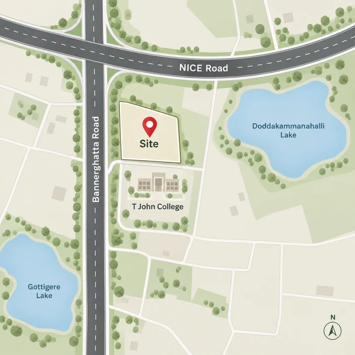
| Address detail | Shriram Bannerghatta |
|---|---|
| Survey numbers | Sy. No. 85/2 and 85/3 |
| Village and hobli | Kammanahalli village, Begur Hobli |
| Taluk and PIN | Bengaluru South taluk, PIN 560083 |
| Landmark | Beside T John College, off Bannerghatta Road |
| South edge | T John College Road |
| East edge | Hommadevanahalli Road |
| North | The NICE Road, just beyond the site |
The 4.95-acre site lies on the Doddakammanahalli and Gottigere side of Bannerghatta Road, with the T John College campus as its neighbour. Its registry village, Kammanahalli in Begur Hobli, is a different place from the better-known Kammanahalli near Kalyan Nagar in east Bengaluru, so use the full name - Kammanahalli village, Begur Hobli - with T John College as the landmark whenever you check land records or share directions.
North along Bannerghatta Road lie Hulimavu, Arekere and JP Nagar, established neighbourhoods that supply many of the schools, hospitals and shops listed below. Shriram Bannerghatta is in pre-launch as at 24 September 2026; its approvals and launch timing are set out on the overview.
02 — Roads
Shriram Bannerghatta Road Connectivity
Two of South Bengaluru's main roads cross within about 2 km of Shriram Bannerghatta, and that junction is the location's everyday advantage. The NICE Road runs just north of the site; its nearest entry, at the Bannerghatta Road interchange in Gottigere, is within about 2 km by road. Bannerghatta Road itself is about 2 km by road, at the same interchange.
The NICE Road is a tolled expressway that runs east and west along the city's southern edge, linking Bannerghatta Road with Kanakapura Road to the west and Hosur Road at Electronic City to the east. From the Gottigere interchange, Kanakapura Road and Hosur Road can both be reached without crossing the city centre, at the cost of a toll on each trip.
Electronic City can be reached two ways, and the figure depends on where you work there. The Wipro campus on the Neeladri Road side is about 8.3 km by road via Begur-Koppa Road; the Infosys campus gate is about 14.7 km via the NICE Road. Begur itself is about 5.7 km.
Towards the city, Central Silk Board junction, where Hosur Road meets the Outer Ring Road, is about 10 km by road. Road distances say nothing about peak-hour traffic on Bannerghatta Road, so drive your own commute at the hour you would make it before you decide.
03 — Metro
Shriram Bannerghatta Metro Access
For a home off Bannerghatta Road, the Pink Line is the metro that matters. The elevated Pink Line along Bannerghatta Road, from Kalena Agrahara to Tavarekere, is built but not yet open as at 24 September 2026; BMRCL expects to open it in October 2026. The section has missed earlier targets, so treat October as an expectation rather than a fixed date.
From the site, on the Doddakammanahalli side of Bannerghatta Road, the nearest metro station is Kalena Agrahara station (the stop many people call Gottigere), the southern end of the Pink Line, about 3.4 km by road - not yet open as at 24 September 2026 and expected to open in October 2026. There is no station named Gottigere on the line. Hulimavu station comes next, about 3.8 km by road.
The nearest stations running today are Konanakunte Cross on the Green Line (about 7.4 km by road, via Gottigere and Anjanapura) and Jayadeva Hospital on the Yellow Line (about 7.7 km). Jayadeva Hospital is also planned as the Pink Line's interchange with the Yellow Line, and Hosa Road, another Yellow Line station, is about 9.2 km. Beyond Tavarekere, the Pink Line's underground section towards Dairy Circle and Nagawara is still under construction.
04 — Distances
Shriram Bannerghatta Distance Table
From one address beside T John College, South Bengaluru's roads, metro stations, rail and air links and main employment hubs line up as follows.
Roads and neighbourhoods
| Place | By road |
|---|---|
| NICE Road entry (Bannerghatta Road interchange, Gottigere) | within about 2 km |
| Bannerghatta Road (at the NICE Road interchange, Gottigere) | about 2 km |
| Gottigere | about 1.8 km |
| Hulimavu | about 3.3 km |
| Arekere | about 5.6 km |
| Begur | about 5.7 km |
| JP Nagar 4th Phase | about 6.8 km |
| Central Silk Board junction | about 10 km |
| Jayanagar (Jayanagar metro) | about 11.2 km |
| MG Road (MG Road metro) | about 15.2 km |
Metro
| Station | Line | By road | Status as at 24 September 2026 |
|---|---|---|---|
| Kalena Agrahara | Pink | about 3.4 km | Not yet open; expected to open in October 2026 |
| Hulimavu | Pink | about 3.8 km | Not yet open; expected to open in October 2026 |
| IIMB | Pink | about 5.3 km | Not yet open; expected to open in October 2026 |
| JP Nagar 4th Phase | Pink | about 7.0 km | Not yet open; expected to open in October 2026 |
| Konanakunte Cross | Green | about 7.4 km | Operational |
| Jayadeva Hospital | Yellow | about 7.7 km | Operational; future Pink Line interchange |
| Hosa Road | Yellow | about 9.2 km | Operational |
Rail, air and bus
| Place | By road |
|---|---|
| Bannerghatta BMTC bus stand | about 7.1 km |
| KSR Bengaluru City railway station | about 18 km |
| Kempegowda International Airport | about 50 km |
Work
| Employment hub | By road |
|---|---|
| Accenture, Bannerghatta Road | about 5.8 km |
| Honeywell Technology Solutions, Bannerghatta Road | about 6.0 km |
| Wipro campus, Electronic City (Neeladri Road side, via Begur-Koppa Road) | about 8.3 km |
| IBC Knowledge Park (Dairy Circle) | about 9.9 km |
| Biocon Park, Bommasandra | about 12.1 km |
| Jigani Industrial Estate | about 13.4 km |
| Infosys campus gate, Electronic City (via the NICE Road) | about 14.7 km |
| Embassy GolfLinks Business Park | about 17.5 km |
Distances are from the site by road, as at 24 September 2026. They are not drive times: traffic, and the route you choose, decide how long a journey takes.
The offices along Bannerghatta Road and both Electronic City campuses in this table are within about 15 km by road, so a two-income household with one job on Bannerghatta Road and another in Electronic City can keep both commutes within that range.
05 — Schools
Schools near Shriram Bannerghatta
Families moving up to a larger home will find an established choice of schools within about 6 km by road, with Sherwood High School about 1.4 km away and Greenwood High and Vibgyor High School about 2.3 km each.
| School | By road |
|---|---|
| Sherwood High School | about 1.4 km |
| Greenwood High, Bannerghatta Road | about 2.3 km |
| Vibgyor High School, Hulimavu | about 2.3 km |
| Carmel Academy | about 2.5 km |
| Mount St Joseph | about 3.0 km |
| Holy Spirit School (ICSE) | about 3.4 km |
| Chrysalis High School, Begur | about 3.6 km |
| BGS National Public School, Hulimavu | about 3.7 km |
| Delhi Public School, Electronic City | about 4.4 km |
| PSBB Learning Leadership Academy | about 5.2 km |
| Ryan International School, Bannerghatta Road | about 5.4 km |
| Christ Academy ICSE School | about 5.5 km |
| Candor International School | about 5.7 km |
For higher education, T John College adjoins the site.
| College | By road |
|---|---|
| AMC Engineering College | about 3.5 km |
| NMIMS Bengaluru | about 4.1 km |
| Christ University, Bannerghatta Road campus | about 4.3 km |
| RV Institute of Technology and Management | about 4.4 km |
| IIM Bangalore | about 5.5 km |
A school run on Bannerghatta Road is shaped by traffic as much as by distance, so make the trip on a school morning before you settle on a school.
06 — Hospitals
Hospitals near Shriram Bannerghatta
Several of South Bengaluru's major hospitals line Bannerghatta Road to the north of the site, from Apollo and Fortis at about 5.6 km and 5.7 km by road to the Sri Jayadeva Institute of Cardiovascular Sciences, for cardiac care, at about 7.9 km. Vijayashree Hospitals in Gottigere is about 1.9 km.
Check which of these your health insurer lists as network hospitals, and learn the route to at least two of them.
| Hospital | By road |
|---|---|
| Vijayashree Hospitals, Gottigere | about 1.9 km |
| Apollo Hospital, Bannerghatta Road | about 5.6 km |
| Fortis Hospital, Bannerghatta Road | about 5.7 km |
| Rainbow Children's Hospital, Bannerghatta Road | about 6.3 km |
| Sri Jayadeva Institute of Cardiovascular Sciences | about 7.9 km |
| Aster RV Hospital, JP Nagar | about 8.7 km |
| Kauvery Hospital, Electronic City | about 13.6 km |
07 — Leisure
Shopping, Lakes and Leisure near Shriram Bannerghatta
Everyday shopping starts close to home: DMart in Gottigere is about 2 km by road. The nearest mall is Royal Meenakshi Mall, about 3.4 km by road; Centro Mall on Bannerghatta Road is about 5.0 km, and three more malls sit about 7.3 km to 7.5 km away.
The lakes around Gottigere give the area its green breaks: Doddakammanahalli Lake and Gottigere Tank are each about 1.4 km by road, so open water and trees are part of the immediate neighbourhood rather than a trip across town.
| Place | Type | By road |
|---|---|---|
| Doddakammanahalli Lake | Lake | about 1.4 km |
| Gottigere Tank | Lake | about 1.4 km |
| Kalkere Arboretum | Arboretum | about 1.6 km |
| DMart, Gottigere | Supermarket | about 2 km |
| Kalena Agrahara Lake | Lake | about 2.8 km |
| Royal Meenakshi Mall | Mall | about 3.4 km |
| Hulimavu Lake | Lake | about 5.0 km |
| Centro Mall, Bannerghatta Road | Mall | about 5.0 km |
| Bannerghatta Biological Park (entrance) | Park | about 7.0 km |
| Forum South Bengaluru | Mall | about 7.3 km |
| Nexus Vega City | Mall | about 7.4 km |
| Gopalan Innovation Mall | Mall | about 7.5 km |
| Nexus Koramangala | Mall | about 11.1 km |
08 — The national park
Shriram Bannerghatta and the Bannerghatta National Park
Shriram Bannerghatta takes its name from the road it sits off, not from the national park to the south. This is the city end of the Bannerghatta Road corridor - Bannerghatta village and the Biological Park are about 7 km further south by road. The Biological Park is a weekend outing from here, not a neighbour.
The site lies outside the Bannerghatta National Park eco-sensitive zone as notified in March 2020, which extends 100 m to 1 km from the park boundary. The extent of that zone is under review in the Supreme Court as at 24 September 2026, so check its status again before you buy.
The environmental clearance application is pending, as at 24 September 2026. Before you book, ask for the site's position on the zone map in force at the time, and have your lawyer confirm it. Shriram Bannerghatta is not yet registered with K-RERA, and no registration number has been issued as at 24 September 2026. Check the registration yourself at rera.karnataka.gov.in before you pay anything.
The masterplan sets out the four blocks, the landscaped spine and the parking on this site. Register your interest to receive the launch details as Shriram announces them.
Questions
Shriram Bannerghatta Location FAQs
How far is the NICE Road, and is it tolled?
The NICE Road runs just north of the site; its nearest entry, at the Bannerghatta Road interchange in Gottigere, is within about 2 km by road. It is a tolled expressway, so regular trips on it add a toll to the running cost of a commute. It is also the route to the Infosys campus gate in Electronic City, about 14.7 km by road.
Is the Gottigere metro station open?
Not yet. The stop many people call Gottigere is Kalena Agrahara station, the southern end of the Pink Line on Bannerghatta Road, about 3.4 km by road from Shriram Bannerghatta. The station is built but not yet open as at 24 September 2026, and it is expected to open in October 2026. Until then, the nearest stations running today are Konanakunte Cross on the Green Line, about 7.4 km, and Jayadeva Hospital on the Yellow Line, about 7.7 km.
What is the nearest metro station to Doddakammanahalli?
Measured from Shriram Bannerghatta, on the Doddakammanahalli side of Bannerghatta Road, the nearest metro station is Kalena Agrahara, where the Pink Line ends, about 3.4 km by road; Hulimavu, one stop further north, is about 3.8 km. The Pink Line is built but not yet open as at 24 September 2026, and it is expected to open in October 2026. If you need a train before then, the nearest stations running today are Konanakunte Cross on the Green Line (about 7.4 km) and Jayadeva Hospital on the Yellow Line (about 7.7 km).
Which schools are close to Shriram Bannerghatta?
Sherwood High School is about 1.4 km by road, Greenwood High and Vibgyor High School, Hulimavu are about 2.3 km each, and Carmel Academy is about 2.5 km. Further out, Delhi Public School, Electronic City is about 4.4 km and Ryan International School on Bannerghatta Road about 5.4 km. All distances are by road from the site, as at 24 September 2026.
Which hospitals are close to Shriram Bannerghatta?
Vijayashree Hospitals in Gottigere is about 1.9 km by road. On Bannerghatta Road, Apollo Hospital is about 5.6 km, Fortis Hospital about 5.7 km and Rainbow Children's Hospital about 6.3 km, and Sri Jayadeva Institute of Cardiovascular Sciences is about 7.9 km. All distances are by road from the site, as at 24 September 2026.
Is this the Kammanahalli near Kalyan Nagar?
No, these are two different places. Shriram Bannerghatta is in Kammanahalli village, Begur Hobli, Bengaluru South taluk (PIN 560083), off Bannerghatta Road in South Bengaluru. The better-known Kammanahalli near Kalyan Nagar is in east Bengaluru. When you search for or share the address, use Kammanahalli village, Begur Hobli, or simply off Bannerghatta Road beside T John College.
Is Shriram Bannerghatta near Bannerghatta National Park?
No. Shriram Bannerghatta is at the city end of the Bannerghatta Road corridor, beside T John College and just south of the NICE Road, and the Bannerghatta Biological Park entrance is about 7 km further south by road. The site lies outside the Bannerghatta National Park eco-sensitive zone as notified in March 2020, which extends 100 m to 1 km from the park boundary. The extent of that zone is under review in the Supreme Court as at 24 September 2026, so check its status again before you buy.
Enquire about Shriram Bannerghatta
Be among the first to hear when the villaments at Shriram Bannerghatta open for booking. Shriram Properties is targeting a launch in October-December 2026, and the details that decide a purchase - the price list, the unit plans and the K-RERA registration - will be confirmed at launch.